 Hyperlocal Weather
A hurricane tracker for every storm on Earth
Hyperlocal Weather's hurricane tracker puts named tropical systems on a live map — category, sustained and gust winds, central pressure, movement, dated forecast track points and an uncertainty corridor. Press play and watch where the storm goes next. Atlantic hurricanes, Pacific typhoons and cyclones alike, on iPhone & Android.
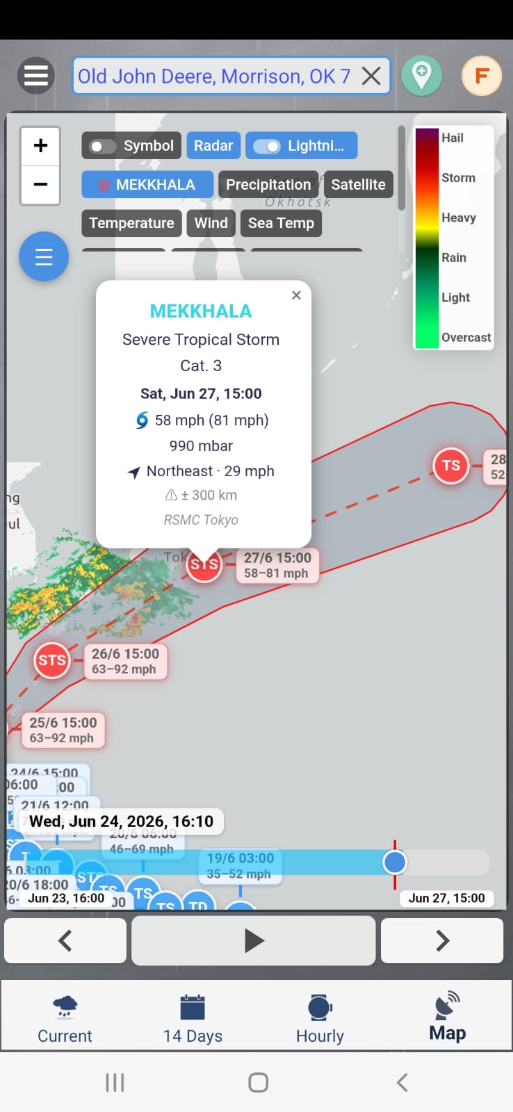
Everything a storm card should tell you
Hurricanes on the same live map as radar
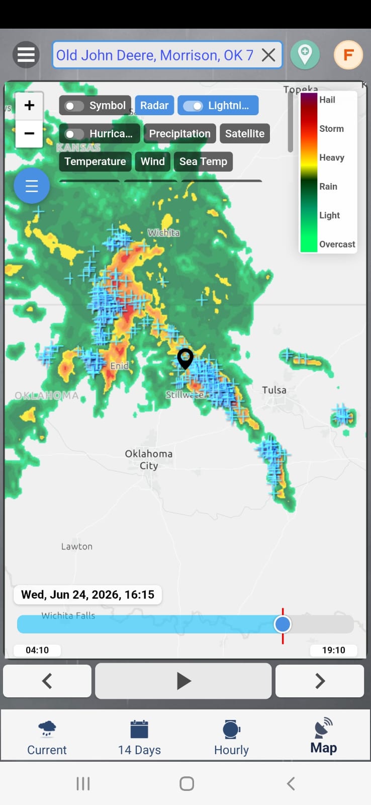
The hurricane layer lives on Hyperlocal Weather's interactive map alongside live radar, lightning strikes, precipitation, satellite, temperature, wind and sea temperature — flip layers on and off with a tap and see the storm's rain bands and lightning in context.
- Layer chips for Radar, Lightning, Hurricane, Precipitation, Satellite and more.
- Intensity legend from light rain up to hail and storm-strength echoes.
- Play the timeline to animate the map and follow the system's motion.
Know when the rain bands reach you
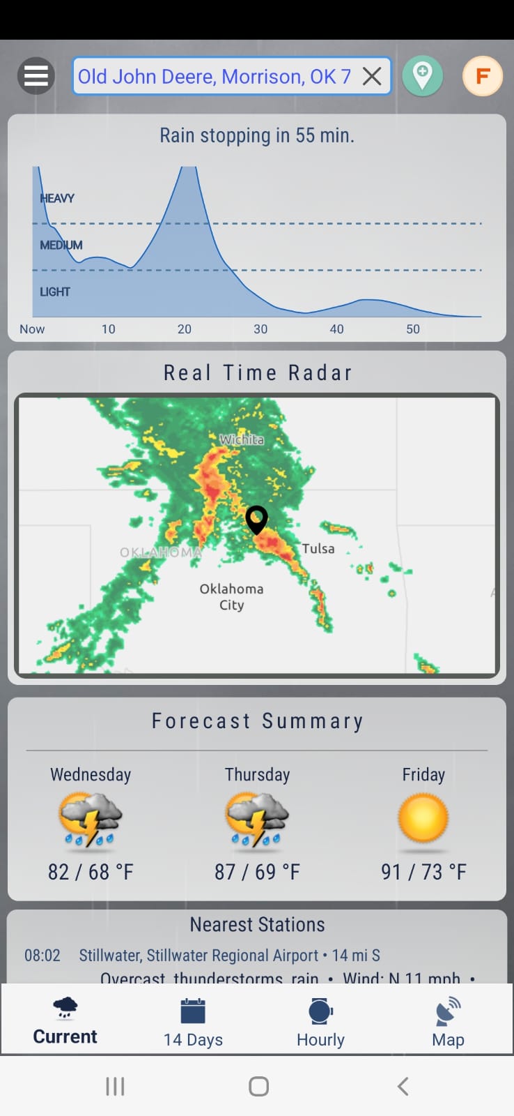
A storm tracker is only half the story. While the hurricane layer shows the big picture, the minute-by-minute nowcast tells you exactly when precipitation starts and stops at your coordinates — down to "rain stopping in 55 min."
- Next-hour curve for rain at your exact location.
- Real-time radar beneath the forecast, on one screen.
- Plain-language summary of what's coming next.
Hurricanes, typhoons and cyclones — worldwide
The same tropical system gets a different name depending on where it forms — hurricane in the Atlantic, typhoon in the western Pacific, cyclone elsewhere. Hyperlocal Weather tracks them all on one map, with official agency attribution such as RSMC Tokyo, so a typhoon tracker for Japan and a hurricane forecast map for Florida are the same app.
How to read a hurricane tracker map
A good hurricane tracker answers three questions: how strong is the storm, where is it now, and where is it going? On Hyperlocal Weather's map, each named system carries its full vitals — category, sustained wind speed with gusts in brackets (for example 58 mph (81 mph)), central pressure like 990 mbar, and its current movement direction and speed. Lower pressure and higher winds generally mean a more dangerous storm.
Forecast track and the uncertainty corridor
The projected path is drawn as dated forecast track points, each marking where the storm's centre is expected on a given day. Around the track sits an uncertainty corridor — for example plus-minus 300 km — which widens further into the future because storm paths become harder to predict. If your location sits inside the corridor, keep watching even if the centre line misses you. Every track is attributed to the official agency that issued it, such as RSMC Tokyo for the western Pacific.
Watching a storm alongside radar and alerts
Because the hurricane layer shares a map with live radar, you can pair the big-picture storm tracker view with the fine-grained picture of where rain is falling right now. Explore the animated radar forecast to see precipitation move hour by hour, follow strikes with the lightning tracker, and switch on rain alerts so your phone warns you before the outer bands arrive.
- Coastal residents tracking whether a tropical storm tracker line bends toward their shore.
- Travellers and sailors checking typhoon tracks across the Pacific before a trip.
- Family abroad following a cyclone near loved ones from anywhere in the world.
- Weather watchers replaying the timeline to see how a system develops.
Hurricane tracker questions
What does the hurricane tracker show for each storm?
Tap a named system on the map to see its category, sustained and gust wind speeds — for example 58 mph (81 mph) — central pressure such as 990 mbar, and its current movement direction and speed. Each storm also carries an attribution to the official agency behind the data, such as RSMC Tokyo.
Can I see where a hurricane is going next?
Yes. Every storm comes with dated forecast track points and an uncertainty corridor — for example plus-minus 300 km — so you can see the projected path and how confident that path is. Press play on the timeline to watch the storm move along its forecast track.
Does the tracker cover typhoons and cyclones, or only Atlantic hurricanes?
It covers tropical systems worldwide, not just the Atlantic basin. Typhoons in the western Pacific and cyclones elsewhere appear on the same map layer, so users in Japan, Australia, Singapore and beyond can follow the storms that matter to them.
Is the hurricane tracker free on iPhone and Android?
Yes. Hyperlocal Weather is free on iPhone and Android, and the hurricane layer is part of the same interactive map that includes radar, lightning, precipitation, satellite and more. Wear OS is included with the Android app, and a separate standalone Apple Watch app is also available.
Related storm tools
Track every storm, everywhere
Get Hyperlocal Weather and follow hurricanes, typhoons and cyclones on a live map — iPhone, Android and worldwide.